
-
 Hurricane Idalia has strengthened and accelerated its approach northward Tuesday. (NATIONAL HURRICANE CENTER)
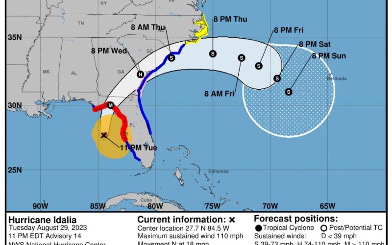
Hurricane Idalia, which strengthened to a Category 2 system with winds strengthening to 110 mph by Tuesday evening, is now projected to come ashore early Wednesday as a Category 4 system with sustained winds of at least 130 mph in the lightly populated Big Bend region, where the Florida Panhandle curves into the peninsula.
The National Weather Service in Tallahassee called Idalia “an unprecedented event” since no major hurricanes on record have ever passed through the bay abutting the Big Bend.
At 11 p.m. Tuesday, Idalia was about 125 miles west of Tampa, the National Hurricane Center said. It was moving north at 18 mph.
Gov. Ron DeSantis as well as Chief Financial Officer Jimmy Patronis and Kevin Guthrie, the state’s emergency management director, urged residents to state safe during the storm at a press conference Tuesday afternoon at the Columbia County Combined Communications Center. The state officials also stressed the importance of making wise decisions after Idalia passes as well.
“This storm is going to impact inland counties, particularly in northern Florida you are going to see significant impacts,” DeSantis said.
The storm, which was expected to make landfall in the Big Bend portion of Florida between 8-10 a.m. Wednesday as a Category 3 hurricane before continuing its northeast track, which included Columbia, Suwannee, Lafayette and Hamilton counties in its path.
DeSantis stressed the storm’s path included more than just those areas projected inside the cone.
“There’s going to be impacts outside whatever the National Hurricane Center says is the path of the storm,” he added.
Patronis, reiterating the governor, said people will lose power. However, Patronis warned Florida residents from worsening the storm’s impacts by making bad decisions once Idalia has moved out of the area.
He said there will be “predators” ready to pounce as soon as the storm passes, having been staged outside the area prior to its arrival.
Patronis said those individuals will offer services, like removing trees from houses or other cleanup efforts, sometimes for cash, sometimes by requesting people to sign contracts or other agreements.
“If you feel comfortable with giving a total stranger cash at your doorstep, you might as well be setting it on fire because that’s what you’re doing,” Patronis said, adding his office as well as Columbia County Sheriff Mark Hunter and the local deputies will do their best to protect residents’ rights.
“Those that come out immediately after a storm, a lot of times don’t have the best of intentions. They’re going to seize that opportunity to take advantage of you because you’re vulnerable. Do not sign anything.”
But once Idalia has passed and it is safe, both Patronis and DeSantis said the state will have response teams out doing search and rescue missions as well as cleaning up debris.
DeSantis said by Tuesday night, nearly 40,000 linemen were expected to be in the state to help with power restoration after the storm. Additionally, DeSantis said the state has 1.1 million gallons of fuel on standby in case of any fuel interruptions due to the storm. Also, hundreds of crews are ready to assist with “cut and toss” operations for debris cleanup.
“You will lose power if you’re in the path of this storm,” he said. “You should assume that’s going to happen. The goal is going to be rapid restoration of power.
“Some of the parts where this storm is projected to go are a lot of trees. There’s going to be a lot of branches, a lot of trees, a lot of power lines down, just expect that.”
Patronis and Guthrie, too, were adamant that power outages were to be expected.
“We live in paradise,” Patronis said. “Sometimes Mother Nature likes to show up and give us a haymaker or two, but I promise you we’ll get through this together.”
That will happen, Columbia County Emergency Management Director Shayne Morgan said because of people working together ahead to time to prepare for the storm.
“We’re preparing for the worst, but hoping for the best,” Morgan said.
Locally, mandatory evacuations have been ordered for certain residents in both Suwannee and Lafayette counties.
Suwannee County Sheriff Sam St. John, the county’s emergency management director, issued a mandatory evacuation order Monday for all county residents that live in mobile homes, travel trailers and structurally compromised housing. Those living in low-lying and flood prone areas or living in homes that have previously flooded during heavy rains also face mandatory evacuations by noon Tuesday.
“You do not have to leave the state. You don’t have to drive hundreds of miles," DeSantis said Tuesday morning at the state’s emergency operations center. “You have to get to higher ground in a safe structure. You can ride the storm out there, then go back to your home.”
Suwannee County is opening three shelters at noon Tuesday. A pet-friendly general population shelter will be open at Suwannee Pineview Elementary, 1748 Ohio Ave. S in Live Oak, while another general population shelter will open at Branford Elementary, 26801 State Road 247 in Branford. A special-needs shelter for medically-necessary residents will be available at Suwannee Springcrest Elementary, 1419 Walker St. SW in Live Oak.
St. John issued the order based on executive orders from DeSantis and a Suwannee County Commission resolution declaring a state of emergency for the county due to the impending storm.
Lafayette County Emergency Management also issued a mandatory evacuation order Monday for residents in those same types of structures by 6 p.m. today. The county is not opening a shelter due to expected winds in excess of 110 mph. Instead, the county is urging residents to go to Branford Elementary or Suwannee Pineview Elementary.
Emergency shelters are also opening at 6 p.m. Tuesday in Columbia County at Fort White High School, 17828 SW State Road 47 in Fort White; Richardson Community Center, 255 NE Coach Anders Lane in Lake City; Winfield Community Center, 1324 NW Winfield Street in Lake City; Westside Community Center, 431 SW Birley Avenue in Lake City; and Westside Elementary, 1956 County Road 252B, which is serving as a special needs shelter.
Self-service sandbag locations are open in Columbia County until 7 p.m. at the County Public Works office, 607 NW Quinten Street in Lake City; Southside Sports Complex, 1963 SW Bascom Norris Road in Lake City; and Fort White ball fields, 17579 SW State Road 47 in Fort White. There is a 15-bag limit. The City of Lake City has sandbags available until 5 p.m. at the Public Works Department, 180 NE Gumswamp Road in Lake City.
There is 10-bag limit per vehicle.
In Suwannee County, sandbag fill locations are available at the Live Oak Fire Department, 200 Duval St. NE in Live Oak; the Suwannee County Judicial Annex, 218 Parshley St. SW in Live Oak; and the Branford Volunteer Fire Department, 602 SW Suwannee Ave. in Branford.
Utilities, including Duke Energy Florida and Florida Power & Light, have more than 25,000 workers stationed to help restore electricity. The state also has activated 5,500 members of the Florida National Guard.
Because of the speed of the system, rescue operations might begin by sunset Wednesday, Guthrie said.
“These are going to be very, very delicate tactical operations. They may be done from the river. They may be done from creeks. They may be done from helicopters,” Guthrie said. “It's not something we like to do, which is operating in a dark environment with power lines entangled in trees. But, again, we understand that people are probably going to call 911 and need some assistance.”
“You do not have to leave the state. You don’t have to drive hundreds of miles," Florida Gov. Ron DeSantis said Tuesday morning at the state’s emergency operations center. “You have to get to higher ground in a safe structure. You can ride the storm out there, then go back to your home.”
Many school districts along the Gulf Coast were to be closed through at least Wednesday, including Columbia County, Suwannee County and Lafayette County. Several colleges and universities also closed, including the University of Florida in Gainesville. Florida State University in Tallahassee said its campus would be closed through Friday.
Idalia's initial squalls were being felt in the Florida Keys and the southwestern coast of Florida on Tuesday afternoon, including at Clearwater Beach. Workers at beachside bars and T-shirt shops boarded up windows, children skim-surfed the waves and hundreds of people watched the increasingly choppy waters from the safety of the sand.
After landing in the Big Bend region, Idalia is forecast to cross the Florida peninsula and then drench southern Georgia and the Carolinas on Thursday. Both Georgia Gov. Brian Kemp and South Carolina Gov. Henry McMaster announced states of emergency, freeing up state resources and personnel, including hundreds of National Guard troops.
Editor Jamie Wachter and the Associated Press contributed to this report.