Columbia County officials are looking to make changes in the county’s Comprehensive Plan that could create more economic development opportunities by expanding the Designated Urban Development Area near the Interstate-10 interchanges.
The proposed amendments to the Future Lane Use Map are designed to result in a change of permitted densities, intensities and overall land use entitlements near the I-10 and U.S. Highway 41 interchange that has been identified by county staff as an area that is appropriate for future economic development.
During Thursday’s County Commission meeting, after hearing a presentation from Connie Brecheen, the county’s community development coordinator, commissioners unanimously approved the proposal.
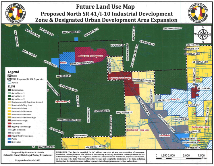
The lands are located near the U.S. 41 and I-10 interchange in the unincorporated areas of the county. The subject property includes lands both to the east and west sides of U.S. 41 and north and south of I-10.
The site, roughly 4,147 acres, is in three zoning categories. The majority of the property is zoned Agriculture 3, which is 87% of the site - roughly 3,637 acres - mixed use zoning, 7.5% of the site - about 312 acres of the site - and public use, 4.8% percent of the site consisting of 198 acres.
The changes that officials approved would consist of a few new zoning categories, creating a commercial highway interchange (21 acres), industrial zone (1,572 acres), light industrial zone (393 acres), public land use zone (300 acres) and residential land use zone (1,861 acres).
The commercial highway interchange zone would allow for tourist-oriented facilities, retail outlets, truck stops and facilities for the storage and distribution of foods and products including wholesale activity.
The industrial zone would allow manufacturing, assembly processing or storage of products, as well as public, charter and private school teaching sites for industrial arts curriculum. Off-site signs, truck stops and automotive service stations could also be approved as special exceptions.
The light industrial zone would be an area for storage, warehousing, wholesaling and distribution and light manufacturing and processing in completely enclosed facilities.
The public land use zone would allow sewer facilities, solid waste facilities, drainage facilities, potable water facilities, public health facilities and educational uses.
The residential land use zone would address dwellings for low density at two per acre and very low density at one dwelling per acre.
Brecheen noted that the effects of the proposed DUDA expansion would allow Agriculture 3 zoning to remain at 3,637 acres, eliminate 312 acres for the mixed use district, while increasing the public use zone from 198 to 300 acres.
The proposed changes will be sent to the state for review.
May 27, 2026
Extended Search
