
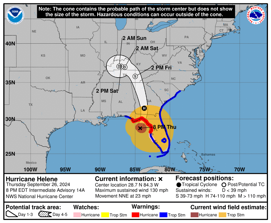
Helene strengthened into a Category 4 hurricane hours ahead of its expected landfall on Florida’s northwest coast Thursday night, and forecasters warned that the enormous storm could create a “nightmare” surge in coastal areas and bring dangerous winds and rain across much of the southeastern U.S.
Helene prompted hurricane and flash flood warnings extending far beyond the coast up into northern Georgia and western North Carolina. Strong winds already cut power to over 320,000 homes and businesses in Florida, according to the tracking site poweroutage.us. The governors of Florida, Georgia, Alabama, the Carolinas and Virginia all declared emergencies in their states.
The hurricane was about 115 miles south of Tallahassee and had sustained winds of 130 mph, according to the U.S. National Hurricane Center. Accelerating through the Gulf of Mexico, it was moving north-northeast at 23 mph, and life-threatening storm surges of up to 20 feet were expected in the Big Bend area of Florida.
Columbia County officials began making preparations for local impacts on Wednesday. With the area still rebounding from Hurricane Debby in late August and the subsequent flooding it caused, local officials expressed concern during a special County Commission meeting that an abundance of rain could result in more flooding in the area.
“I pray that we don’t get as much rain as they predict we’re going to get,” said Ron Williams, Columbia County Commission Chairman, as he opened the meeting.
Shayne Morgan, Columbia County Emergency Director, informed the group that the storm has been rapidly organizing and was expected to make landfall in the Big Bend area Thursday as a major hurricane, possibly as a Category 4, but there was still potential for the storm to shift back to the east, potentially passing closer to Columbia County.
Projected rain level amounts are 3-7 inches.
“The closer east, the more impactful it will be for our county, the farther west it may provide a little more leniency,” Morgan said.
Morgan also made sure to explain the difference between Helene and other recent storms, namely its size.
“This is a big storm,” he said. “Even though what the cone shows, it will eventually go well outside that cone of error. Impacts will be felt, unfortunately, I’ve heard as much as 200 miles wide of this storm. We will see impacts. It’s just a matter of where it actually tracks as to how far they will go.”
The county’s Citizens Information Center opened Wednesday and was expected to begin with 24-hour operations Thursday morning so people in the building could answer questions from the public, so residents don’t tie up 911 lines with non-emergency questions. The CIC number for storm-related questions is 386-719-7530.
Four general population and one special needs shelter will be open, starting Thursday morning. Those shelters will be located at:
- Winfield Community Center, 1324 NW Winfield St.;
- Fort White High School Gym, 17828 SW State Road 47;
- Deep Creek Community Center, 1193 N. US Highway 441;
- Richardson Community Center, 255 NE Coach Anders Lane; and
- Westside Elementary School (Special Needs Only), 1956 SW County Road 252B.
Williams asked that the shelters remain open after the storm has passed the area, so that people who were impacted by loss of electricity or water would have a place for a shower and the use the restroom.
Keven Kirby, Assistant County Manager, said the public works department’s employees will mobilize at daylight on Friday and will “cut and toss” any trees across roadways.
Kirby asked that a curfew be imposed, but Columbia County Sheriff Mark Hunter said emergency vehicles don’t venture out when winds are 45 mph and above and there would be no authorities available to enforce a curfew at the height of a storm with hurricane force winds.
“If you choose to go out, you’re on your own,” he said of people who may venture out during the storm.
Kirby, like Williams, also noted that most local retention ponds are full.
“We are saturated…,” he said. “When somebody says we need to pump water, that’s going to be a challenge. Where do we pump it?”
The county is offering sandbags beginning at 7:30 a.m. until conditions worsen, at:
- Columbia County Public Works, 607 NW Quinten St.,
- Fort White Community Center, 17579 State Road 47, Fort White, and
- Southside Sports Complex, 1963 SW Bascom Norris Drive. (Elderly or special needs residents should go to Columbia County Public Works for help in getting sandbags.)
In addition to the schools being closed on Thursday and Friday, Columbia County Courts have been suspended through the weekend. The Columbia County Tax Collectors, Columbia County Property Appraisers Office, Columbia County libraries, Extension Service Office and Clerk of Courts will be also be closed on Thursday and Friday.
The Columbia County Supervisor of Elections Office will be closed to the public Thursday, but open to the public on Friday if possible.
County trash collection will start 5:30 a.m. Thursday and will continue as wind speeds allow throughout the day. Weather and roadways permitting, pickup is planned to resume on Friday.
By 10 a.m. more than 200 vehicles had gone to Southside Sports Complex to collect 15 sandbags per vehicle.
Charles Edens, Country Skillit owner, was one of more than a dozen people on site filing sandbags to protect his home or business. With a generator and multiple fuel canisters in the bed of his pickup truck, Edens, his son and top server continuously filled sandbags.
He said he planned to have the restaurant open Thursday to 3 p.m. as long as the weather permitted and as long as they had electricity.
“I’m heading to the store to put the sandbags down in the front — one section is a little lower, just to be safe and make sure we’re cautious with the water,” he said, as he wiped sweat from his brow. “I feel that we should be alright. We’re on the main strip of electrical lines and the water, so we should hopefully still have power and electric to help out whoever doesn’t have it.”