
Forecast calls for 1.5-2 inches of rain after landfall.
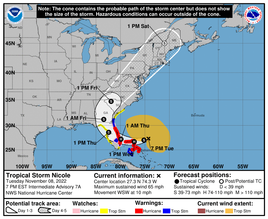
Tropical Storm Nicole churned toward the northwestern Bahamas and Florida's Atlantic coastline on Tuesday and was forecast to develop into a hurricane over the next couple of days, forecasters said.
The hurricane center said the storm's track shifted slightly north overnight, but the exact path remains uncertain as it approaches Florida, where it is expected to make landfall as a Category 1 hurricane late Wednesday or early Thursday.
Columbia, Suwannee and Hamilton counties were placed under a tropical storm watch at the 4 p.m. advisory from the National Hurricane Center.
Columbia County Emergency Management Director Shayne Morgan said Monday that the county has already been working the phones with the National Weather Service in Jacksonville, which said the forecast for Columbia County called for about 1.5-2 inches of rain as it moves through the area.
“The projections are for it to move west-to-southwesterly through the Atlantic across the state of Florida,” Morgan said. “It’ll hit hurricane strength around the Bahamas area, but then it will die back down to a strong tropical storm across the state and go into the Gulf.”
Morgan further explained that once the storm reaches the Gulf of Mexico, Nicole isn’t expected to pick back up in intensity as the cooler water there will prevent that.
However, by the time the storm potentially reaches North Florida, Morgan said there could be some negative effects from Nicole in the region.
“I would say that probably, it might be a little bit greater impact than Ian, because we didn’t get much off of Ian at all,” Morgan said. “We might see some winds from this, but like it is with any storm, it all depends on the actual trajectory that it takes. If it moves up on shore a little bit further north, we might see some more wind and some rain. If it moves further south to come across the state, then we might not see as much wind and rain.
“It’s really a flip of the coin at this point.”
Morgan said the best thing residents can do to prepare is to keep an eye on any updates coming from the county or state levels while also getting their hurricane plans ready again.
“If you haven’t done it yet this year, go ahead and go through your family’s response plan,” Morgan said. “What would happen, what you would do, in the case that something happened and you did have to leave your home. Make sure everybody knows what it is they’re going to do, where your meetup points are going to be, those kind of things.
“It’s not just a hurricane season preparedness, it’s year-round for any disaster that would happen.”
By Tuesday night, hurricane warnings were issued for a large portion of Florida's Atlantic Coast, from Boca Raton to north of Daytona Beach. Tropical storm warnings are in place for other parts of the Florida coast, all the way to Altamaha Sound, Georgia.
The warning area also stretches inland, covering Florida's Lake Okeechobee, with tropical storm watches in effect on the state's Gulf Coast from Bonita Beach in southwestern Florida to the Ochlockonee River in the Panhandle. The tropical storm watch extends north to the South Santee River in South Carolina.
At 7 p.m. Tuesday, the storm was about 250 miles northeast of the northwestern Bahamas and 360 miles east of West Palm Beach. It was moving at moving at 10 mph, with maximum sustained winds up to 65 mph.
— The Associated Press contributed to this story