
Fast-moving storm could cause damage as it passes through.
The fast-moving Tropical Storm Eta is expected to impact North Central Florida today as it makes its way towards the Atlantic Ocean.
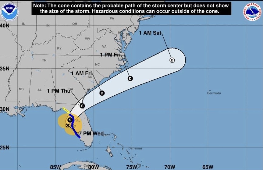
How big of an impact, though, depends on just how quickly the storm progresses, according to Shayne Morgan, Columbia County’s Emergency Management director.
“If it maintains its speed is expected to be going off into the Atlantic Ocean by about 1 p.m. (today),” Morgan said. “Depending on where it comes on shore and whether it’s closer to us or farther away from us is really going to determine what our impacts are.
“The farther away it comes on shore it will be the less impacts we’ll have. With a fast-moving storm, rainfall won’t be as big of an issue and flooding, but because it has sped up, we’re going to have the possibility of those winds in the pre-dawn hours. That may cause issues if the winds get up to the 30-35 mph.”
Morgan said preliminary forecasts indicate that there wouldn’t be a direct impact to Columbia County, but the storm’s outer edges could still cause issues locally.
The storm was expected to hit the area as early as 1-2 a.m. today, although there could still be storm conditions around 11 a.m.
“A lot of it depends on where the storm actually comes ashore and how close to Columbia County it is,” Morgan said.
Still, the forecasts from the National Hurricane Center on Wednesday evening were calling for tropical depression force winds — up to 30-35 mile per hour sustained winds — and several inches of rain.
“We could see some gusts that are higher,” Morgan added. “It doesn’t necessarily mean we’re going to reach that level, but that’s the forecast amount on the high end as far as what we can see.”
Morgan said a lot of rain falling in a limited amount of time could cause some flash flooding in the area, but once the ground catches up and is able to process the rainwater, the flooding will only be temporary.
“It will not hit us as a hurricane and it’s not looking like it’s going to make direct impact,” he said. “It looks like once it comes on shore, it’s going to deteriorate rapidly — so, at worse we’re looking at it probably being a depression as it moves through and across the state of Florida.”
Still, those winds were Morgan’s biggest concern Wednesday.
“That could blow down some trees if the soil is saturated or power lines could go down,” he said. “There may be power outages…People should be aware that the possibility is there of downed limbs, trees and power lines and to use caution if they have to go out.”
Late Wednesday afternoon, the Columbia County School District notified parents, employees and students that because of the projected impact of Eta on the area, the decision had been made to close school on Thursday. Suwannee County Schools canceled late Wednesday morning.